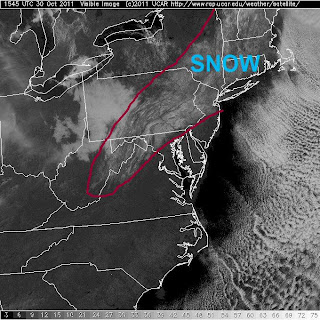
It was a snowy October day . . .
... and a record-breaking early snow it was. The surface low and upper trough took a classic track - intensifying off Norfolk and moving up the east coast just offshore. Some of the totals are very impressive: >20" in several states. For October, when the waters and ground are still relatively warm, this was an especially significant event.
On the western shore of the Chesapeake, we didn't see any accumulation, but we did see flakes flying at mid-day Saturday. Points to our west (Frederick, Hagerstown, etc) and north into PA and NJ saw far more snow than we did (Frederick ~3"). Here's a satellite from Sunday a.m. showing the accumulation swath.


0 Comments:
Post a Comment
<< Home