Desierto norte de Chile

Monday, August 06, 2012

A long hiatus

In the 3 (gasp!) months since I've last posted:

- Factor accompanied me to Greenville for Easter weekend;
- The 2012 Spring Semester ended on a positive note, with all of my students passing and all of my capstone students graduating;
- I led SWIFT-2012 through nearly 8,000 miles of storm spotting out on the Great Plains;
- I traveled with Casimiro, Jose, and Factor to New York City (and West New York, NJ, just across the Hudson River);
- I spent a week North Carolina with family, celebrating the life of my Uncle Bill, who passed away during our vacation there;
- I have written 2 draft papers for submission to Weather and Forecasting and Journal of STEM Education;
- I have another paper in the works for submission to Atmósfera;
- Five tropical cyclones have formed in the Atlantic basin; and
- Blogspot has undergone a wholesale renovation of its web site!

Many things have been happening.  I'll put up some pictures soon. 

Sunday, April 01, 2012

Spring is here

Happy April 1st - spring is here. That means warmer weather, longer days, and lots and lots of pollen! It also means that spring break has come and gone, and that the academic year is rapidly coming to a close. Additionally, spring is the peak of the U.S. severe weather season, and so a daily query of SPC and the various NWP models usually brings some excitement.

Since it's been an entire *month* since I last posted (I blame Facebook, although I'm on there far less than I used to be), here are some updates from my world.

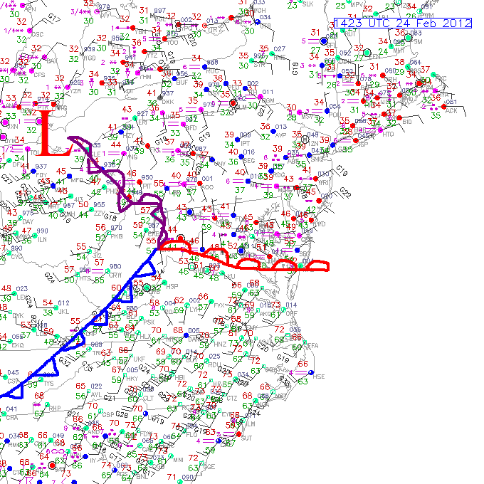
1. One month ago the U.S. was in the grips of a tornado outbreak in the Midwest (IN/OH/KY/TN). Today the weather is fairly benign, although tomorrow will be interesting with the approach of a closing-off low over OK/TX coupled with moisture & instability.

2. The past 6 days have been hard - a nice combination of sore throat, dry cough, diarrhea, fever, chills, sweats, and general malaise! Fortunately I'm on the mend, but still have the cough & sore throat. I'm settling on heartburn as the cause, although it could be anything from allergies (no other symptoms for that, though) to a cold/flu/virus (also no other symptoms). Regardless I will be very ready to put this behind me!

3. Classes. Being sick last week, class content essentially got glossed over. This week will have to make up & put in extra time to (re)cover the topics lost (or poorly explained in the fever-induced delirium). My capstone students are staring down the barrel at their paper due-date, which is Wed 11 Mar. I look forward to reading & seeing the presentations of their final products.

4. SWIT. The now-annual juant to the plains with USNA students is coming up very soon. We leave in less than 6 weeks. It's a little weird that this year we've had trouble keeping all of our 10 participants, but the group we've got looks to be great!

5. Chile. I had the great chance to lead 4 students back to Chile 3 weeks ago. We got to visit with Francisco & Araceli, go to church at Comunidad Cristiana de Santiago, tour the US Embassy and Chilean Naval Academy, visit Punta de Choros, and experience lots of great Chilean food & hospitality. This Tuesday, God-willing (with this sickness & sore throat!), I'm the guest of the USNA Superintendent, Admiral Miller, as he hosts the Chilean Superintendent in Annapolis. I look forward to hablando mas Chileno :)

6. Ecuador. The students and I left Chile and immediately went to Ecuador for 4 days, where we visited an Ecuadorian Naval Base, toured an Oceanographic survey ship, visited the U.S. Embassy in Quito, and had a great time in Mindo National Reserve forest.

7. Easter. I plan to head south in 5 days to spend the Easter holiday with my family. Hopefully Mike, Kendra, Rhett, and Axel can join us on Saturday. Maybe some of my friends from small group here (Factor, Jose, Casimiro, and/or Baltazar). Probably a pretty low chance that even one of them would be able to come, but still hoping that they might be able to! Best chance is if the forecast is for a lot of rain.

8. Speaking of rain, this winter, while being warm, was pretty below-normal w.r.t. precipitation here in the mid-Atlantic. Not complaining one bit, because we get plenty of rainfall here anyway (50"+ per year, so even a 10" deficit isn't bad).

I'll try to put up some pictures of Spring, of Spring Break, and the like in the coming days.

PS: Today being April 1st, April Fool's Day, Google showed what its maps might look like on the Nintendo system (similar to the original Legend of Zelda maps!!) Here's a screen capture of the USA in "8-bit".

Friday, March 02, 2012

Relationship between SRH and CAPE

I saw this figure on a friend's Facebook feed and wanted to repost it. Really nice collection of plots of CAPE and 0-1 km SRH combinations for deadly tornadoes over the last 11 years. Figure from Jon Davies (available here).

Our first high risk of the year

Today SPC has issued a high risk (for tornadoes) for the Ohio river valley region. Part of the risk for tornadoes hinges on just how much low-level helicity there will be, and low-level helicity (at least the storm-relative part, SRH) depends heavily on storm motions. If storms move more easterly, they will have very high amounts of SRH to work with, and likely produce tornadoes. If they move more northeasterly, SRH will be correspondingly lower.


Friday, February 24, 2012

Warm and blustery, or cool and drizzly?

Today's weather will be very interesting. A warm front is located about 200 km south of Annapolis, and the NWS predicts it to come north of us today (so high temperatures near 70F), then a cold front passing later this evening with rain and thunderstorms. I'm more skeptical, as temperatures in the upper 40s now (at 9:30 a.m.) and drizzle indicating the cool, stable layer is still well entrenched over us. Will be interesting to see what happens, as the severity of the afternoon precipitation strongly depends on the position of the surface warm front. My afternoon bicycle ride home could be quite interesting!

Sunday, February 19, 2012

That was likely our last chance at snow...

The weak surface low slowly intensifying in eastern NC this afternoon will likely be our last chance at appreciable snow this winter. For us in the mid-Atlantic, the large majority of our snow comes from interacting upper-tropospheric vorticity maxima that phase to promote strong surface cyclogenesis. Cold air from our north is advected in at the surface while moist air from the south is advected aloft. The last week of NWP forecasts have bounced all around with how they treat today's low, but ultimately the phasing between vorticity centers didn't happen, so the slowly intensifying low will move essentially east from N. Carolina later this afternoon. Had it moved northeast (driven by a more amplified upper-troposphere wave), it would likely have brought us snow today/tonight. However we'll be lucky now to see even flurries. All in all, a disappointing "flourish" to a throughly non-snowy year. Since July 1, BWI has received 1.8" of snow: 0.4" on 09 Jan, 0.9" on 21 Jan, and 0.5" on 11 Feb. The total is 17.7" below the median annual snowfall value of 19.5". If it stands for the year (a reasonable outcome), it would be the 3rd least snowy winter in Baltimore since 1883 (1949-50 with 0.7", and 1972-73 with 1.2", are the 1st and 2nd least snowy, respectively).

Thursday, February 16, 2012

Snow on Sunday?

It seems like an eternity has passed since my previous post (in reality, it's been only 36 hours!) The many model initializations since Tuesday and this morning have all had varying solutions for the coastal low, ranging from a dry, cirrus-y day to a heavy rain and thunderstorm type of day. The latest couple of model runs have seemed to converge on a solution that looks snowy. Still many questions regarding rain/snow for Annapolis - given our very warm winter and associated warm surface temperatures that will need to be overcome. But the predictions are encouraging, and point to snow during some point of the event (right now at the end, once the surface low begins to move away and the surface layer can cool enough to support frozen precip). Here's the GFS forecast for 10 a.m. Sunday.

Tuesday, February 14, 2012

Happy Valentine's day: will it snow over the weekend?

Happy Valentine's Day to all! After following the NWP models nearly daily for the past 2+ months, we finally have a couple of solutions that indicate a potential for a snowstorm over the weekend. Will be worth following over the next couple of days- to see whether the major upper-troposphere players (various amplitude shortwave troughs in the north and south) phase together to promote surface cyclogenesis that moves up the coast, or whether they stay separate and result in a weak low that moves essentially east into the Bahamas. Here's a forecast of MSLP, 6-hr precip, and 850-hPa temp from the GFS.

Monday, February 06, 2012

I'm guilty, too

In a blog post in the Spanish daily newspaper El País (of Madrid), there's a nice series of articles about traveling. This figure caught my attention more than most: the mean number of vacation days earned by citizens of various countries, and the number of vacation days actually taken (and, naturally, the number of unused days). My country, USA, comes in 3rd to last in the group, only ahead of work-a-holic Japan and South Korea. Even Mexico and India earn - and take - more paid vacation days than we do. I wonder why it is, that we both earn few, and take even fewer, vacation days?

I admit it, though: I'm guilty, too, of not using all of my 'precious' vacation days. Perhaps because the academic semester is so loaded, that taking vacation during the teaching term is frowned upon. Equally likely is that because the summer schedule is so flexible, that I don't feel the same need to take vacation days because I already am resting when compared with the other 3/4ths of the year. Those are probably my reasons, but I'm curious the justification of the rest of the country.

Wednesday, February 01, 2012

Warm and snow-less

This winter continues its warm and snow-less march to spring. The current temperature here in Annapolis is 67F, and today's high temperatures here and to our west might top out at 70F! For the first day of February, warmth like that is impressive.

What is governing this warmth? While the atmospheric system is incredibly complex, it often can be diagnosed effectively through the use of climate indices: two that are popular are the El Niño-Southern Oscillation (ENSO) index, and the North Atlantic Oscillation (NAO). ENSO measures sea surface temperatures in the tropical eastern Pacific ocean and NAO measures sea level pressures between Iceland and the Azores islands. While the causality of both remains debatable, the effects of each are pretty well known: both affect the frequency, amplitude, and translation of planetary waves, which in turn affect cloud cover, precipitation, and temperature.

The NWS Office in Sterling, VA (who forecasts for us here in Annapolis) has put together a great brief on the combined effects of ENSO & NAO on snowfall in Washington, DC. Their presentation is found here (which came from the media agenda here), and at the Washington Post here.  The years with above-normal snowfall (>15.5" in a year) almost always occur during a negative phase of the NAO, and the majority of the snowy years occur when ENSO is either neutral or warm. The combination of those two yields upper-level troughing and below-normal temperatures over the eastern 2/3rds of the U.S.

The current ENSO Index is -0.979, and the NAO index is around +0.25. On the phase-space diagram from the NWS, that puts us in the upper-left quadrant- the one with the least snowy years. Furthermore, and even less encouraging, is the ensemble NAO forecast, which calls for mostly +NAO for the next 2 weeks. By the time the NAO goes negative again, we'll be heading toward spring!


    ‹Older