9:00 PM 19 Dec
This will be my last update. What a snowstorm it was! I remember thinking back on Monday, after querying the NOGAPS and GFS models, "hmm, we could get some snow over the weekend..." As each successive run of the numerical models continued to show snow, my interest (and excitement) grew. NWS-Sterling began mentioning the possibility in its discussions mid-week, but naturally were hesitant to forecast large snow accumulations several days out. They issued a winter storm watch, followed by a winter storm warning, on early Thursday and Friday mornings, respectively, and were confident in heavy accumulations by Friday afternoon. I went grocery shopping on Thurdsay, and the store was tranquil. I stopped by Safeway on Forest Drive about 9 p.m. last night and it was a mess (it usually is a hassle anyway, with few registers open, and this was just worse: the lines were snaking down the aisles). The snow began by 10 p.m. Friday evening and now, about 24 hours later, is finally ending. I'm not sure how long it will take for the snow to melt, but for sure lots will still be on the ground come Christmas day. Here are my final totals (I'm not going to go measure the last few hundredths... I'm exhausted and am off to bed!)
Storm total accumulation as of 9 p.m.: 22.3"
New snow, from 10 a.m. to 9 p.m.: 11.8"
Old snow, prior to 10 a.m.: 10.5"
Snow on ground at 9 p.m.: 19"


---------------------
Earlier posts and real-time updates:
I've decided to live-blog the impending snowstorm (christened "Winter Wallop" by The Weather Channel). I've placed two snow boards (1x10" pieces of wood) around my house and am ready with my yardstick. Why a 'yardstick' you ask? Because the forecast is for more than 12" of snow by the end of the event (Sunday a.m.). We'll see how much falls. The NWS has officially gone for 1-2 *feet* of snow, which if the high end of that fell, would represent near record snows for this area. Enjoy the live-blog and photos below.
-----------------------
7:00 PM 19 Dec
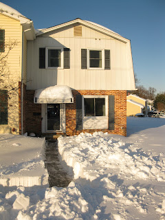
Well looks like the event is finally winding down. The broken bands that appeared around 3:00 on the radar were only temporary as the precipitation expanded and intensified again by 4 p.m. In the pics below you see where my car was parked, on the side street, which gave me two headaches: (1) the side street was plowed at least twice, resulting in my car getting hemmed in by a large, rocky pile of snow; (2) our parking lot was also plowed twice and the plow driver decided to pile the snow up where I normally park, just behind my apartment. This snow will probably be there through mid-January, melting in the day and giving me an icy parking spot for several weeks. Ugh. Here are the latest snow totals and some pictures from the last light of the afternoon.
Storm total accumulation: 20.8"
New snow, from 10 a.m. to 7 p.m.: 10.3"
Old snow, prior to 10 a.m.: 10.5"
Snow on ground at 7 p.m.: 18"


3:12 PM 19 Dec
The end is coming. The LWX radar shows that the southwest end of the precipitation shield is breaking up into banded elements, and actually right now Annapolis is between two of the bands (giving us much lighter snow compared to earlier). Basically we've had 17" of snow in 17 hours, not bad for a winter storm!

2:45 PM 19 Dec
New snow since 10:00: 7.0"
Total event accumulation: 17.5"
Current snow on ground: 16.0"


1:15 PM 19 Dec
New snow since 10:00: 5"
Total event accumulation: 15.5"
Current snow on ground: 14.0"

11:20 AM 19 Dec
New snow since 10:00: 1.5"
Total event accumulation: 12.0"
Current snow on ground: 11.5"
I cleared a new spot (tried to get a level space far from buildings or trees) and placed a new snow board, cleared at 1500 UTC. Thus the totals from 10:00 onward will reflect the snow board AND total on ground. This will allow me to try to account for compaction.


10:20 AM 19 Dec
New snow since 07:15: 2.7"
Total snow on ground at 10:00 a.m.: 10.5" (Some spots with 11" but hard to get exact totals due to drifting).
Radar still showing moderate to heavy snow band over Annapolis. NWS has upgraded the entire WAS-BAL corridor to Blizzard Warning status.


08:40 AM 19 Dec
More photos of the surroundings. If the 11Z RUC verifies, we're looking at approximately 1" more liquid-equivalent between now and 00Z today (that's 10" more snow). Wow.


07:15 AM 19 Dec
Update: man a lot happens overnight at an NWS office. NWS-Sterling upgraded our winter storm warning to a blizzard warning (I think this is the first time I've been in a blizzard warning... we'll see if it verifies: >3hr of sub 1/4-mile visibilities and wind gusts >35 kts.
07:10 AM 19 Dec
Wow what a way to wake up! I dreamed the snow had changed to rain, but that was just a dream. No rain to speak of here (although Reagan National reported mix SNPL last hour). My 2 snow boards I placed out are completely buried (I forgot to mark their locations), so my measurement techniques are out the window. I'm not going to wipe anything off anyway because the wind would just blow it right back over. For reference, KNAK was 14G22 last hour, so I think I'm justified in not using the wipe/measure method. Just going to measure and let compaction take its course.
07:10 total: given the drifting around my house I had to take averages: the final total ended up being 8.8". Am sending this report to LWX, NWS Sterling, right now. Here are a few pictures.


10:00 PM 18 Dec
First snow accumulations. About 1/10".

9:20 PM 18 Dec
Light snow has begun in Annapolis! Again, the NWS prediction is for 1-2 feet; The Weather Channel's local forecast calls for "3-5 inches Friday night, 10-12 inches Saturday, and 3-5 more inches Saturday night" (total 16-22"). I've got brownies baking and am ready for what comes (hopefully whatever comes will not bring a power outage with it). The last "pre-event" model run, the 00Z NAM model, has a small swath of 3" liquid-equivalent right over Annapolis. Folks, with a 10-1 snow-to-liquid ratio, that's 30". Wow.


